The aim of the undergraduate course is to train professionals with highly qualified scientific, technical, ethical and professional levels, in the various areas of civil engineering intervention, with the ability to apply high level knowledge. To reach this goal, skills are developed to enable these professionals to design, plan, implement and manage projects in the areas of structures, buildings, water and environment, planning and transport. In addition the following capacities are also developed: use of modern information technology in implementing the various functions that make up the civil engineering professional activities; act in diverse workplaces such as consulting, design, construction companies and construction services, building inspection, planning and transport, management water resources and environment, both government entities and private companies.
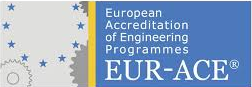
The Polytechnic of Leiria is the first Institute in Portugal to be granted the EUR-ACE® label at the bachelor level in Civil Engineering recognized by ENAEE (European Network for Accreditation of Engineering Education). The accreditation extended to Master in Civil Engineering as well recognizing quality in Civil Engineering programs at School of Technology and Management of Leiria’s Polytechnic. The distinction confirms education quality in these particular field of study placing these programs among the best European universities and polytechnics.
Geodesy: Geoide, Natural and Geodesic Coordinates, Ellipsoids Reference, Geodesic Data, Geographic and Geodesic Coordinates, Geodesic Networks;
Cartography: Cartographic Projections Systems, Cartographic Azimuth; Scale Concept, Cartographic Representation of Land Surface.
Collect and process data acquired: Working with Topographical Equipment, using GPS Receivers and Laserscanning for Acquisition of Information. Perform a small topographic survey with classic methods and collect and process data acquired with GPS receivers and Laserscanning.
Other systems to collect and process acquired data: Photogrammetry, Remote Sensing.
Model surface, Digital Terrain Models using BIM; Reading and interpretation of topographical maps; Visibility Maps; Profiling; calculation of land volumes.
Representation of volumes by their orthogonal projections using European and American methods
Enclosing cube
Freehand sketch and tape survey of constructed elements.
Perspectives
Types of plane geometric projections
Orthogonal Axonometric Projections
Methodology for reading orthogonal projections
Introduction to the CAD system: 2D drawing – 2D graphic entities, editing commands, dimensioning and printing commands).
Definition of designed parts in the field of civil engineering (representation of plans, sections, elevations, construction details, covering various civil engineering specialties
English as a lingua franca. Attitudes towards English.Expressions to convey linguistic and learning necessities.Brief notions of the characteristics that have led English to become a global language.
Informal Conversation: Taking part in conversations about people, places and other topics; description of personal and professional profiles; identification of cultural differences.
Contacts: Starting and keeping conversations about topics related to the professional context via telephone, email or face to face… Describing people and exchanging information.
Meetings: Expressions to set up and organize meetings, make decisions, solve problems, present suggestions and lead meetings. Official register of information. Checking and clarifying facts and figures.
Negotiating relationships: Expression of formality and informality. Expression of likes and dislikes about travelling on business. Discussing attitudes about meetings and cultural behaviours in different countries.
Geology – objects and methods. Introduction to Engineering Geology
The Earth, internal geodynamics: origin, structure and constitution. Earthquakes: origin, seismic waves, earthquake scales, distribution of seismic focus, seismic risk in Portugal, effects of earthquakes on buildings. General requirements anti-seismic construction. Isostasy, continental drift and its mechanisms, plate tectonics, Earth’s age and geological history.
Geodynamics surface processes.
Elements of Mineralogy and Petrology. Classification of rocks occurring in Portugal. Classification with minerals and rocks.
Geological maps. Geotechnical maps and geotechnical zoning maps. Reading and interpretation of topographical maps and geological maps. Execution of topography and geological profiles.
Characteristics of soil identification and soil classification
Effective stress fundamental. State of stress at rest. Stress induced by external forces
Soil with water: One-dimensional fluid flow and Two-dimensional fluid flow.
Consolidation theory. Laboratory tests. Terzaghi consolidation theory. Calculation of settlements through consolidation. Acceleration of consolidation.
Soil compression. The improvement of soil: Theory of Proctor compaction; Execution of compressed landfill and compaction control
Building installations for water supply (supply systems, reservoirs, water consumption in buildings, comfort and quality of systems, design of systems, materials and equipment, hot water production systems, sizing of distribution systems, lifting and overpressure installations, reception of systems, standard EN 806)
Building installations for firefighting with water (introduction, regulatory documentation, firefighting systems, water consumption, reception of systems)
Building drainage of domestic wastewater, rainwater and underground water (introduction, drainage systems, discharge flow rates, design of drainage systems, comfort and quality levels, piping and accessories, sanitary appliances, system sizing, complementary installations, private treatment systems, reception of systems)
Building installations for gas supply (characteristics of fuel gases, design, tests)
Structural design of buildings: basic criteria for the distribution of mass and inertia; modelling for the structural calculation; approaches used in modelling.
Preliminary design of structural members: criteria commonly used in the preliminary design; estimation of static actions applies.
Description and quantification of the different actions presents in a structure: permanent actions; variables actions: overloads; combination of actions.
Modelling of RC structures in a computer program (Finite element analysis)
Interpretation and analysis of test results: output and analysis of the results.
Checking the safety of structural elements: ultimate limit states; service limit states.
Organization of the design process: written and drawn elements
Seminars: Presentation and discussion of selected topics by invited expert speakers, such as “The challenges of digital transformation”, “Responsible leadership”, “CDW management and circular economy”, “Renewable energy and sustainable construction”, “Water distribution and wastewater drainage systems management”, “New technologies and sustainable materials”.